Crack in bluff beside Pacific Coast Highway near Laguna Beach prompts lane closure
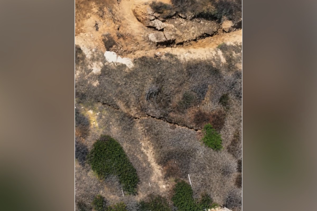
A crack in the eroding bluff below Pacific Coast Highway near Laguna Beach led Caltrans to close a southbound lane. Outlets agree on the closure but differ on how imminent a collapse is.

1 / 2
The story, neutrally told
Mixed · 2A crack has appeared in the cliffside below Pacific Coast Highway (PCH) near Laguna Beach, Southern California, and KTLA reported it on Tuesday 13 October. NewsweekN “KTLA in Los Angeles reported on Tuesday that erosion led to the crack’s formation along a cliffside supporting a portion of the highway near Laguna Beach.” Read at Newsweek ↗ New York PostR “Sky5 footage from KTLA also showed the fractured bluff Tuesday afternoon” Read at New York Post ↗ Mixed · 2Caltrans closed one southbound lane of PCH from Reef Point Drive to Irvine Cove Drive; it said this was a precautionary measure and would stay until repairs are completed. NewsweekN “The agency said it had closed the southbound right lane on Pacific Coast Highway from Reef Point Drive to Irvine Cove Drive “as a precautionary measure,”” Read at Newsweek ↗ New York PostR “Caltrans has closed one southbound lane of PCH from Irvine Cove to Reef Point Drive for emergency work” Read at New York Post ↗ Centre · 1A Caltrans spokesperson told Newsweek the agency is reviewing updated surveys and drone footage to decide on the best way forward, and asked the public to follow detour and speed limit signs. NewsweekN ““Caltrans is reviewing updated surveys and drone footage to determine the most effective path forward,” they said.” Read at Newsweek ↗
Centre · 1Laguna Beach officials said the stretch is outside city limits and under Caltrans' jurisdiction. Acting Public Works Director Tom Perez said the extent and depth of the crack were unclear, and Mayor Mark Orgill said any compromise of exit or entrance routes is a concern. NewsweekN “Laguna Beach officials said Wednesday that the affected portion of the highway is outside city limits and is managed by the California Department of Transportation (Caltrans).”“said in a social media update on Wednesday that the extent or depth of the crack was unclear”““Any time that any of these exit routes or entrance routes are compromised, it’s definitely a concern,” Laguna Beach Mayor Mark Orgill said” Read at Newsweek ↗ Right · 1Local resident Blair Conklin, who filmed the damage for YouTube, estimated the crack is about 10 feet from the road and warned a major collapse could come within days; this is his estimate, as reported by the New York Post citing Surfer. New York PostR “Conklin estimated that crack is roughly 10 feet from the road, according to Surfer, and warned that a major collapse could happen within days.” Read at New York Post ↗ Right · 1The New York Post linked the damage to weeks of heavy surf, high tides and hurricane-driven swells, and said State Parks closed parts of Crystal Cove State Park and San Onofre State Beach and evacuated 26 historic cottages at Crystal Cove after Tropical Storm Rachel. New York PostR “after weeks of heavy surf, high tides and hurricane-driven swells tore into the already battered coastline.”“At Crystal Cove, 26 historic beachfront cottages were also evacuated as a precaution” Read at New York Post ↗
Centre · 1Laguna Beach had proclaimed a local emergency on 10 September over coastal erosion and sand loss from swell from Hurricane Marie, with a very strong El Niño forecast. City Manager Dave Kiff said most people had never seen this much sand leave the beaches at once. NewsweekN “the City of Laguna Beach proclaimed a local emergency on September 10 “in response to coastal erosion and sand loss caused by swell from Hurricane Marie, and the threat of further damage from a forecast very strong El Niño.””“"Most of us have never seen this much sand leave our beaches at once,” City Manager Dave Kiff said in the release.” Read at Newsweek ↗ Right · 1NOAA says El Niño continues to strengthen, with a strong-to-very strong event likely through January to March 2027, and California has declared a state of emergency ahead of a potentially historic winter storm season, according to the New York Post. New York PostR “NOAA says El Niño continues to strengthen, with a strong-to-very strong event likely through January to March 2027.”“California has already declared a state of emergency ahead of the potentially historic winter storm season.” Read at New York Post ↗
Every sentence links to the reporting it rests on. The pill in front of each says where its sources sit: Left, Centre or Right when one side supplies at least half of them, Mixed when they are evenly split. The number is how many outlets it cites.
Left0 outlets
No left outlet in our sources has covered this story yet.
Centre1 outlet
- Framing
- Public-safety notice built on official statements from Caltrans and the City of Laguna Beach.
- Emphasis
- Caltrans' precautionary closure and drivers' instructions, jurisdiction, the city's uncertainty about the crack, and the September local emergency.
- Leaves out or plays down
- Resident's collapse warning and the 10-foot estimate; Crystal Cove cottage evacuations and park closures.
Right1 outlet
- Framing
- Alarm-led account of a 'massive' crack and a road possibly 'inching toward the ocean', built around a resident's video and warnings.
- Emphasis
- Resident Blair Conklin's estimate and warnings, dramatic imagery, and wider storm and El Niño damage including evacuated cottages.
- Leaves out or plays down
- Caltrans' statement that the closure is precautionary, the city's statement that the crack's depth is unclear, and the jurisdiction point.
- Charged language
- “Huge crack”“massive crack”“Escalating quicker”“inching toward the ocean”
- For example
-
“A massive crack near Pacific Coast Highway in Laguna Beach is raising fears that one of Southern California’s most iconic coastal roads could be inching toward the ocean.” — New York Post
What every side reports
- A crack has formed in the bluff near PCH close to Laguna Beach, reported by KTLA on 13 October.
- Caltrans closed one southbound lane between Reef Point Drive and Irvine Cove Drive.
- Erosion from heavy surf and storm swells is the backdrop, with a strong El Niño forecast.
Where accounts differ
-
How imminent is a road collapse
- Centre
- Newsweek reports Caltrans calling the closure precautionary and the city saying the crack's extent and depth are unclear; it reports no collapse prediction.
- Right
- The New York Post relays a resident's warning that a major collapse could happen within days and that part of PCH might crumble into the ocean.
Caltrans organisation
Caltrans says the lane closure is precautionary, it is reviewing surveys and drone footage, and it asks the public to follow detour and speed signs.
““Caltrans is reviewing updated surveys and drone footage to determine the most effective path forward,” they said.” — Newsweek
Pacific Coast Highway place
The highway stretch is outside Laguna Beach city limits and managed by Caltrans; one lane is closed beside the cracked bluff.
“the affected portion of the highway is outside city limits and is managed by the California Department of Transportation (Caltrans).” — Newsweek
Left0 articles
No coverage yet.
Centre1 article
-
Crack Under Pacific Coast Highway Sparks Public Safety Warning
Neutral Relays official statements and a safety warning, noting uncertainty about the crack and the city's earlier emergency declaration.
Right1 article
-
Huge crack spotted next to PCH in elite California beach town: ‘Escalating quicker’
Alarmist Leads with fears of the road falling into the sea, relying on a resident's video and predictions.
- 13 Oct 22:05 First New York PostR Huge crack spotted next to PCH in elite California beach town: ‘Escalating quicker’
- 15 Oct 15:41 +41h 36m NewsweekN Crack Under Pacific Coast Highway Sparks Public Safety Warning
Times are when each article was published, or when we first saw it if the outlet gave no time.
Ask about this story
Loading…